Travel Stories
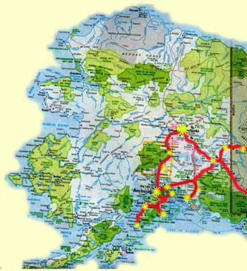
ALASKA
JUNE 10,2007 - September 17, 2007
We left Sacramento on June 10th. We met up with some RV friends in Dawson Creek, Canada. We traveled with them for over three months, as we explored Alaska. We drove over 10,000 miles. A highlight of the trip was having our granddaughter, Nalonni, with us for most of the time. She was such a joy to be with. Be sure to look at all the wonderful pictures (Alaskan Pictures), and read about our experiences (Alaskan Travel Stories).
|
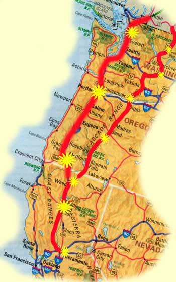
CA-OR-WA |
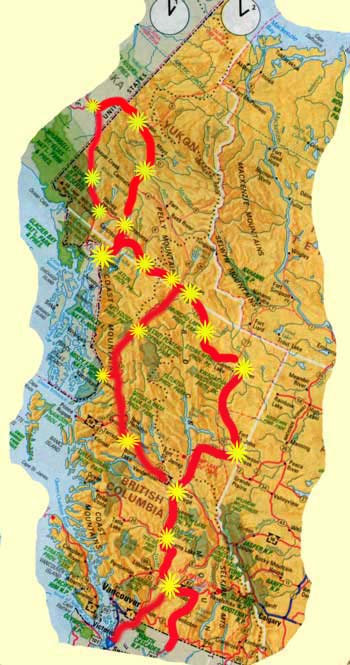
BC-Yukon |
Alaska |
|
Adventures of Krystonia June 18, 2007 On the road to Alaska… We left Sacramento on June 10th. We turned inland at Weed, California and more or less followed Highway 97 north to the Canadian Border. In fact, we are still on Canadian Highway 97 on our way to Dawson Creek. Dawson Creek is Mile 0 of the Alaskan Highway. We will be meeting friends there (six rigs) for our Alaska Adventure. In route, we met with our Portland RV friends, Jon and Lynda who spent four days with us in Washington. From Bridgeport, WA, we headed across the border and they, home. Crossing an international border can be interesting. We crossed at a quiet border where there were no lines, always a preference if it can be arranged. The crossing officials just seem more relaxed and easy going. We were asked the usual questions: “Where are you from? Where are you going? Are you leaving anything in Canada? How much alcohol do you have?” “We are from Sacramento. We are going to Alaska. Yes, we have visited Canada before, great Country, love visiting here. Yes, we have some liquor, but not much.” Then after a little more chitchat we were asked the key question: “Are you carrying any guns?” Arlo: “No guns.” Border Official: “Did you leave them at home?” Arlo: “No, I do not own any guns.” Border Official: “You must be the only person in the US who doesn’t own a gun.” Arlo: “I hope not!” What must the world think of us when we are all perceived as toting guns? Even by our friendly neighbors to the North. On our last trip, we had a workshop on geocaching. It looked like fun and something we could do on the road. Geocaching is said to be the fastest growing sport in the world. It all started in 2000 when GPS (Global Positioning Satellite) signals were released to the public. Prior to that they were only for military use, which are still much more accurate. How it works is that people hide caches with clues and longitude/latitude coordinates. At this time there are over 500,000 caches hid around the world. Using your GPS and observation skills you attempt to find the cache. Then you sign the log and register the find on their web site. Their web site is full of information and tells the locations of all the caches. You can join for free, or pay a small fee for additional services, like automatic downloads. We have found caches in almost every area we have stayed. The fun part is, it takes us places we would probably not see otherwise. Many are related to local history, or places of interest. The advantages are: exercising, puzzle solving (some are very cleverly hid in plain sight), learning new things about our location, and just plain having fun. Take a look at their web site: www.geocaching.com.
***************************** June 30, 2007 On the road to Alaska. Greetings, my name is T Bear. (You can find my picture on our web site with the Alaska pictures.) I have been assigned the duty of writing this newsletter. You may ask who I am and what the “T” stands for. Well the obvious would be Teddy. Wrong. Too many folks with that name, it causes an identity problem. The next best guess would be Thomas Bear. Wrong again, but a good guess because I am part of the Thomas family. I am currently known as Travelin’ Bear. But that wasn’t always my name. I spent nearly 30 years in Dr. Thomas’ office as co-therapist. I was non-judgmental, a good listener, and provided comfort and security to those patients that needed to hug something. In fact I spent a whole week in the hospital with one young lady that needed me. Eventually I was discharged to return to Dr. Thomas’ office wiser to the many problems people experience. But now I am Travelin’ Bear. When Ruth and Arlo leave in their RV they always take the 2 cats and me. I can tolerate the cats and really enjoy the traveling, seeing all the new things. It is very different than being Therapy Bear! We are now on the road looking for Alaska. The Alaska Highway has been beautiful. The mountains and lakes are stupendous. We have been in Canada for most of the trip – it is a long way to Alaska. We went to Skagway for three days. There is only one road into Skagway, so we went in and then back out to Canada. That was exciting; the road elevation changes almost 3500 feet in just 14 miles. Going down was scary and coming out was slow. Crossing back into Canada, for the first time, the crossing official asked for the rabies certificate on the cats. I had to chuckle, because I did not have to have one. Today we are in Whitehorse, Yukon Territory, Canada for 2 days. From here we will go to Stewart Crossing and to Dawson City for three days. On July 5th we will be in Chicken, Alaska. We are still deciding if we want to take the Top of the World Highway between Dawson City and Chicken. It will depend on the weather and the condition of the road. I understand that much of it is not paved. Love the adventure! Be sure and look at our web site: www.krystonia.info. Besides the picture of me there are some pictures from our trip of mountains and lakes.
******************************* Adventures of Krystonia
July 8, 2007
Between Stewart Crossing and Dawson City we stopped at a rest area for a break. While there an interesting truck and trailer also stopped. The trailer, not an RV, attracted our attention. One of our party had to ask about it and soon we were all there to hear the story of the interesting trailer. Turns out that it belonged to James “The Mushroom Man.” The trailer was for drying mushrooms. James was friendly, outgoing and enjoyed telling his story. We learned that Morel mushrooms prosper in the forest after forest fires. That is where the highest gourmet quality mushrooms are found. Each year following the fire the quality decreases. James heads out as soon as he can in the spring and spends the season searching forest fire areas for mushrooms. Often he goes in with an ATV or sometimes by helicopter and stays until the area is fully picked. He then brings them to his trailer where he can dry 800 pounds at a time. They are then sent to Sierra Madre Distributors in Southern California for packaging and shipment to stores. We asked about buying some mushrooms. He had none with him but said that his partner had some and asked where we were staying in Dawson City. Later that evening he came by our RV Park with a case of mushrooms.
James favorite way of fixing them was to stuff them with game meat such as elk or moose, “stinky cheese” and bake them in the oven at 300 degrees for a couple of hours. We asked about mosquitoes. His answer was to let them bite you all they want early in the season. He claimed that this creates immunity and they stop biting you…
Dawson City was in the heart of the Klondike gold rush. Located on the Yukon River, it still maintains its turn of the century feel with wooden sidewalks and dirt streets. Many of the buildings have changed little in over 100 years. Jack London’s Cabin is restored for visitors. Robert Service lived in Dawson City when he wrote the “Cremation of Sam McGee”. His cabin is also available for visitors where they do readings in the evenings.
At this point on our journey we are off the Alaskan Highway and on the Yukon Loop. The challenge is the Top of the World Highway from Dawson City to Chicken, Alaska. This is a 120-mile dirt road with spectacular scenery and views that go on forever. In an RV, it is an all day drive that starts with a Ferry crossing of the Yukon River. The Ferry holds about two RV’s plus a few cars and requires driving up a dirt ramp to get on. Be sure to look at the pictures of both the Ferry and the Top of the World drive.
Chicken was established in 1903 as a mining camp. It got its name from the plentiful Ptarmigan in the area. One story has it that the early miners wanted to name their camp “Ptarmigan” but were unable to spell it and settled for Chicken instead.
We seem to be having a problem finding time to do the Travel Stories. A lot has happened since Chicken to write about. So here is a preview of things to come: From Chicken we returned to the Alaskan Highway and spent about a week in Fairbanks. Granddaughter Nalonni joined us in Fairbanks. We drove 70 miles above the Artic Circle. We are now in Denali National Park headed toward Anchorage. We will write about these adventures as time permits.
****************************************
Adventures of Krystonia July 30, 2007 The Alaskan Highway goes for 1422 miles from Dawson Creek, BC, through the Yukon Territory, to Delta Junction, Alaska. We took the Yukon Loop, turning north at Whitehorse, going through Dawson City; Chicken, Alaska and back to the Alaskan Highway just south of Tok, Alaska. The Yukon Loop is about 500 miles. We will catch the part of the Alaskan Highway we missed on the return trip. We stayed in the Sourdough Campground in Tok. Ken and Amy run this park. Amy was born in Tok. Ken worked for Red Lion and Hilton Hotels for nearly 20 years. His job was project manager for start-ups and remodels. This required frequent moves across the country. One day Amy pointed out to him that he was miserable in his job. She suggested that he quit his job and they move to Alaska. They come to The Sourdough RV Campground as managers and ended up buying it 4 years ago. Ken is a high energy individual with a creative sense of humor. The password for their Internet service is "Happy" which pretty much symbolizes the parks philosophy. There is live entertainment every evening followed by a sourdough pancake toss. If you can get your pancake in the bucket you get a free breakfast of... Sourdough pancakes. Amy fixes a wonderful evening meal to eat during the evening entertainment and Ken does the Pancake breakfast. Ken is also one of the evening performers, singing and telling jokes. He has written several songs including: "The Moose Song", "Torn Up Roads Again", and "Alaska, I'm Home". What a fun place to stay. We will be stopping there again on our return trip. For High School graduation we flew our granddaughter Nalonni to Fairbanks to spend a few weeks with us in Alaska. She arrived on July 10th. The Dalton Highway was built as a service road for the Alaskan pipeline. It runs for about 500 miles from just north of Fairbanks to Prudhoe Bay. Most of it is still dirt with large potholes, ruts, rocks, mud and occasional washouts. It is still used as a service road for the pipeline with the principal traffic being large tanker and supply trucks. These are very large trucks; we counted 32 wheels on one. Although courteous, they "own" the road, driving as if it were a paved interstate with little regard to the potholes. Locally the Dalton Highway is known as the Haul Highway and the drivers as Haul Drivers. About 200 miles north of Fairbanks it crosses the Artic Circle, another 70 it comes to Coldfoot and 17 miles further it comes to Wiseman, AK. At the Artic Circle there is a pull off with a marker indicating the Artic Circle. In Coldfoot, there is a modern Parks Visitor Center, a gas station, a place to eat and a "motel". Wiseman is a small Alaskan Village, population 25. We drove to Wiseman and stayed two nights in a bed a breakfast. Nalonni, who has a Learner's Permit to drive in California, drove all the way to the Artic Circle and much of the way back. She learned how to dodge potholes, shift into four-wheel drive in the mud and pull over and stop to the let the trucks by going either direction. Stopping not only gets you out of their way, but also is prevention against flying rocks hitting the windshield. She is now officially a "Haul Driver". I am struggling on how to describe Wiseman. Of the 25-person population nearly half are children. Other than a Bed and Breakfast and a small lodge, there is no business in town. The accommodations are primitive, rustic and built using mostly local materials. Other than the small income from the lodging, the citizens are "subsistence livers". They are allowed one moose per family per year. They trap small animals in the winter and grow vegetables in the summer. In the summer it is mostly sunny. The day we were there (July 13th) was the first sunset since May 31st. We did not stay up to watch it! That reverses in the winter when it gets down to 60 degrees below zero. We met June who has lived in Wiseman since the 1960's. Two of her children still live there, Jack and Heidi. June cooks and heats with wood. She has a large bank of batteries and an inverter when she needs electricity; her son charges the batteries with a generator. They are very isolated from the rest of the world except for the few visitors they get who are brave enough to tackle the Haul Highway. We stayed 2 nights and found the residents to be very special folks who have a sense of peace about them that we have never found anyplace else. Watch for upcoming Travel Stories about Denali National Park, Mt. McKinley and landing on a glacier at almost 7,000 feet. ******************************************* Adventures of Krystonia August 2007 One reason for travel besides seeing new things is expanding your view of the world we live in. Often this results in an expanded vocabulary. Not surprising, as an RVer, the new words are references to road conditions. On this trip we have learned several new words and new meanings of others. The big one on this trip is "Frost Heaves." Frost heaves are the result of freezing and thawing of the soil under the pavement. They are not something you want to drive over going fast. When we travel in a group, we stay in communication using a CB radio. The lead driver warns us of upcoming road conditions that require slowing down. At first I thought they were saying "Frosties" and I started to look for an ice cream place to slow down for. Other words we have learned are: pavement breaks, gravel patch, broken road and, of course potholes. In fact pothole has a whole new meaning. We never knew there were so many different kinds of potholes. Denali National Park was originally established to protect its large mammals, not because of majestic Mount McKinley. Charles Sheldon conceived the plan to conserve the region as a national park. A naturalist, hunter, and conservationist, Sheldon first traveled here in 1906 and again in 1907. Largely due to his efforts, Mount McKinley National Park was established in 1917. Its population of Dall sheep and other wildlife were now legislatively protected. However, Mount McKinley itself was not wholly included within the boundaries. Sheldon wanted to call the park Denali, but his suggestion would not be followed until 1980. In 1917 Mount McKinley National Park was established as a wildlife refuge. In 1980, the Alaska National Interest Lands Conservation Act (ANILCA) enlarged the boundary by 4 million acres and redesigned it as Denali National Park and Preserve. At 6 million acres or 7,370 square miles, the park is larger than Massachusetts. It exemplifies interior Alaska's character as one of the world's last great frontiers for wilderness adventure. It remains largely wild and unspoiled, as the Athabascans knew it. On December 20,1980, President Jimmy Carter signed the bill establishing Denali National Park. Because of its size, Mt. McKinley creates its own weather which means that it is in clouds most of the time. It is rare and special to see it. One of our group got up very early one morning and was able to see the mountain. We got up at 4:30 am and drove about 15 miles into the Park to where it could be viewed. You can see the pictures of the beautiful clouds early in the morning on the Alaska Pictures page of our web site. From Denali we moved to Talkeetna. This is a wonder small Alaskan Village and the location of Talkeetna Air Taxi. Our group charted an airplane to fly the mountain. The morning we flew the weather broke, the clouds lifted and Mt. McKinley appeared in all its glory. The flight was fantastic. We landed on a glacier about 7,000 feet up the mountain. Some of the pictures are on the Alaska Pictures page. After Denali we explored the Kenai Peninsula. Stories and pictures to come. ******************************************* Adventures of Krystonia September 2007 Anchorage, Alaska is not unlike many mid sized cities in the US. Anchorage has rush hour traffic, “big box” malls, Costco, Wal-Mart and R.E.I. It even has one of the best Mexican restaurants we have ever eaten in. It also has things not found in other mid sized US cities. There is the Alaskan ULU Knife factory and store. (http://www.theulufactory.com/) There is the Alaskan Fur Exchange where you can buy Bulk Fur among other things. “Our furs are professionally tanned and are of the highest quality, color and density. We carry a full range of furs in many different species. For Example: Wolf, Wolverine, Lynx, Fox, Beaver, Mink, Raccoon, Muskrat, Rabbit, Skunk, Ermine, Land Otter, Sheared Beaver, Coyote, and more.” (http://www.alaskafurexchange.com/) There is Humpies where, with a glass of Alaskan Amber you can get the finest fish and chips anywhere. (http://www.humpys.com/) And there is the winter weather! On December 22, Winter Solstice, there is 18.5 hours of darkness. There is a lot of snow and temperatures that drop down to forty degrees below zero. We have trouble imagining what this must be like. As we walked the streets of Anchorage in July, we tried to picture what it must be like six months later. We were just not able to do it. Maybe this means that an Alaskan trip in the winter is called for. It would be fun to fly up for the start of the Iditarod and then on to Nome for the finish. Arlo has a great-grandfather who ran a store in Nome between 1898 and 1903 during the Gold Rush Days. After we left Talkeetna we explored the Kenai Peninsula. Located just south of Anchorage, the peninsula is accessible by highway but is surrounded by water and filled with mountains and spectacular views in every direction. To get there you must go around the Turnagain Arm of the Cook Inlet. Turnagain got it’s name from early explorers who discovered that it was a dead end requiring them to turn their boats around, again. We visited Seward and the Exit Glacier, Soldotna, and Homer, where we camped on the spit with the ocean on one side of us and the bay on the other.
|
This site was last updated 09/25/08